
22 July 2022
Back on the Lake Superior Circle Route, we headed east from Omicron Falls State Park. Road noise, rain, and trains kept us from getting much rest.

Shortly after getting underway, the blades of a windmill had us pulling over in South Range, Wisconsin. The 1904 Davidson Windmill wasn’t the only historic structure here. Built by Finnish immigrant Jacob Davidson, locally grown grains were milled here until 1927. Restored by members of the Old-Brule Heritage Society, the blades started turning again in 2007.

Tying the tiny historic area together is the 1930 Taylor’s Bridge.

Wooden bridges aren’t known for long lifespans, so it’s nice to see folks preserved the last Queen-post style bridge in the state.

Moved from Blueberry, this tiny depot served the Northern Pacific Railway Company from 1885 until the 1950’s.

Following Highway 13, our first glimpse of the big lake came at 0830 through a clearing filled with wildflowers.

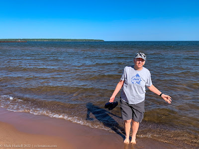
Highway 13 continued along the shoreline for another 45 minutes where we pulled off in the village of Cornucopia. A short sandy path to the beach reminded us of the outer banks at home in North Carolina–until we felt the water temperature!

Weathered gray buildings could have been at home on any seacoast.

Old fishing boats lined the roadway. Among the 32 commercial fishing boats that once called Cornucopia their home port, these boats were referred to as “Fish Tugs” by locals.

Some are in better condition than others.

A few gift shops, chandleries, and restaurants surround the small harbor.

Twilite, built in nearby Bayfield in 1937, was the best preserved fishing boat. She boasting a fresh coat of paint and a shed protecting her from the weather.

A few Fish Tugs still set out from Cornucopia in search of Whitefish and Lake Trout. Wood has been replaced by steel, but the basic design, a fully enclosed pilot house for protection from Lake Superior’s challenging weather, remains the same.

After Cornucopia, the highway leaves the lakeshore and crosses the Bayfield Peninsula, rejoining the shoreline at Red Cliff. Much of the peninsula shoreline is Indian Reservation or National Lakeshore. Leaving highway 13, we drove north, arriving at the Apostle Islands National Lakeshore visitor’s center in Little Sand Bay. Inquiring about camping options, a ranger referred us to the nearby Town of Russell campground. One site was available for $40/night, but we choose to move on since it was still early in the day.
Passing through Red Cliff and Bayfield, we decided to stay in the area for a few days to explore the towns and National Lakeshore. It was time to seriously look for a campground.

By lunchtime we were in Washburn where we stopped at Thompson’s West End Park to see if they had spaces, but they did not. After lunch we tried the nearby Memorial Park Campground, but they were also full.

Dry camping with a great view was only $25 a night. Having water aboard, solar panels, and an ample house battery makes stops like this possible.

We could use the campground amenities across the road. Clean, hot showers were 75 cents for 5 minutes.

Fresh water is available from an artesian well opened in 1903. Flowing at 54 gallons per minute, it took no time at all to fill a couple of gallon containers with tasty spring water. Over the course of our stay, lots of local residents dropped in to fill containers.

Sunset from our site on the hill was one to remember.

Birches on the tiny island just offshore were illuminated just before the sun sank behind us.

23 July

Amnicon Falls to Washburn – 106 miles
Bonus video: Locals showed us how to drink from the Sprague Well.
Leave a Reply