After rolling up a stiff power cord and dumping the tanks in the chilly 44 degree morning air, we headed west on I-40. Stopping at the Visitor’s Center outside of Nashville, we asked about places to park downtown. Learning that there would be street closures and limited parking due to a road race, we opted to leave Nashville for another time and headed to the small town of Franklin instead.
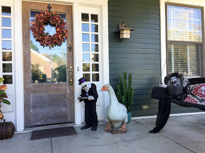
The town was bustling on a Saturday morning, but there were plenty of places to park within walking distance of the shops and historic homes. We enjoyed the creative halloween decorating.
O’More College of Design has a campus in town with attractive older buildings offset with a modern 3D printed sculpture on the lawn.
The
town of Franklin has good planning information on-line if you are contemplating a visit. We enjoyed the town and resisted buying electric bicycles as a rental company closed them out at the end of their season. We decided the exercise associated with our regular bikes is needed it we are going to continue trying out the local cuisine on our travels.
From Franklin we drove down highway 96 to get a view of the famous
Natchez Trace Parkway Bridge. It carries the Parkway 145 feet above the highway with a length of 1,572 feet.
This cathedral arch bridge has won several design awards.
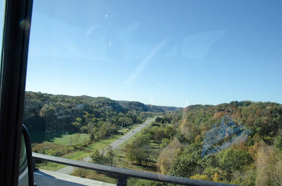
Climbing up from highway 96, we joined the Natchez Trace and began traversing the 444 mile long
National Park. Six miles in we traversed the bridge and looked down on the spot where we snapped a photo. Being a beautiful fall Saturday, there were more bicycles on the road than cars. The speed limit is 40 in this area where hills and tight curves limit visibility. As the Parkway winds south the limit increases to 50 and the road changes to gentle curves through rolling hills on the way to the Mississippi River. The Natchez Trace was a trail used by midwesterners who sold their crops and goods at ports on the Mississippi river. Floating downriver on rafts, the Trace was the hike home before steam powered ships made returning up-river possible. Knowing the history, we are traveling the Trace backwards, starting from the northeast and traveling southwest. The road has mile markers that start here at 444 and count down towards the beginning at 0 in Natchez, Mississippi.
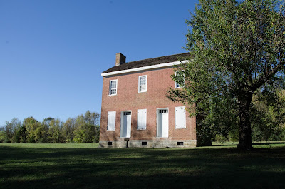
The Gordon House (MM 408) was our first stop. You can read the typical sign provided by the National Park Service.
Moving on, we set our sights for Fall Hollow as a stopping point. Arriving at the falls near dusk, we hiked in to get some photos. We were pleased to see water flowing despite the drought.
A short section of the parkway is closed for repair. When you exit the parkway, Fall Hollow Campground is right across the highway and was an easy place to pull in for the night. For $25 we joined the other campers in a field beside the restaurant. I did wander back up to buy some tasty Cherry Cobbler and take it back to the van for dessert. A group of cub scouts is occupying the more wooded part of the campground.


Leave a Reply