
26 July 2022 Tuesday

We set out on the Doughboy’s Trail. It came highly recommended for waterfalls and canyons. A couple of areas are wheelchair accessible.

Where access ended, we found lots of stairs built by the CCC.

Copper colored water isn’t from copper, but comes from tannin in pine trees.

One modern steel bridge spans the Tyler Forks river. Wide and shallow, the valley of the Tyler Forks cuts across cracks in the underlying basalt.

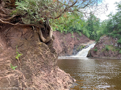
Viewed from the cliff top, the Tyler Forks River drops 30 feet to meet the Bad River. The Bad has eroded a crack in the basalt to form a deep canyon.

And from a lower perspective with a slower shutter speed.

New falls popped into view as we looped back towards the starting point of the trail.

We stopped trying to keep track of waterfall names after the first mile.

Not all of the interesting features were geologic. We were excited to find Ghost Pipe, one of the few plants that doesn’t contain chlorophyl. It, instead, gets energy by hosting fungi.

The Doughboy’s 1.7 mile loop lived up to every recommendation.

Back at the van, we celebrated the Doughboy Trail by enjoying an apple fritter saved from yesterday’s visit to Ashfield.

1142 47,795 Potato River Falls is not on Potato River Rd. They are on Potato Falls Rd, which is bordered on both sides by corn fields.

…then lower, falls.

Lower Falls up close

Downstream, the smooth waters of the Potato River flowed around a cliff revealing layers of geologic time.

27 stories so far today. No signage prohibited camping so, perhaps, it would be okay to boondock overnight. 1304

1335 47,813 Superior Falls 80°

We did keep our ears perked for the flood siren.

The top of the falls are easy to access.

The trail to the bottom of is down a steep road.

The more direct route, via these stairs, was roped off.

Lower view of Superior Falls

Just downstream, the Montreal River gently flows into Lake Superior.

Backtracking two miles into Wisconsin, we found a spot for the night at Saxon Harbor.

The campground has 31 sites. Site 24 was $38 with water, electricity, and a view of the big lake.

Restrooms were modern and clean. A 4 minute shower was $1.00 in quarters.

Facilities are shared with the well-sheltered Saxon Harbor Marina.

Standard boat ramps and a big marine travel lift allow servicing fairly large vessels here. Eighty-seven octane gas at the dock was $5.95 per gallon. That made us feel better about paying $4.39 yesterday.

By evening, Lake Superior was calm, inviting us to look for rocks along the shoreline.


Today’s Route
Leave a Reply